Fully Transparent Pricing
Transparent pricing for web services means that the costs associated with the service are clearly outlined and easily understood by the customer. This includes all fees, taxes, and any additional charges. This allows customers to make informed decisions about the service and avoid any surprises or hidden fees. It also helps to build trust between the customer and the service provider.
Friendly & Trustworthy Service
Our team is made up of honorable individuals who really want to advance your cause and are easy to get ahold of anytime.
Professionally Edited
Photos & Videos
Not tech savvy? Don’t worry! We can post process the entire project for you.
Health & Safety Risk
By following these best practices, a drone business can help ensure that their customers have a safe and enjoyable experience while minimizing the risk of accidents or injuries.
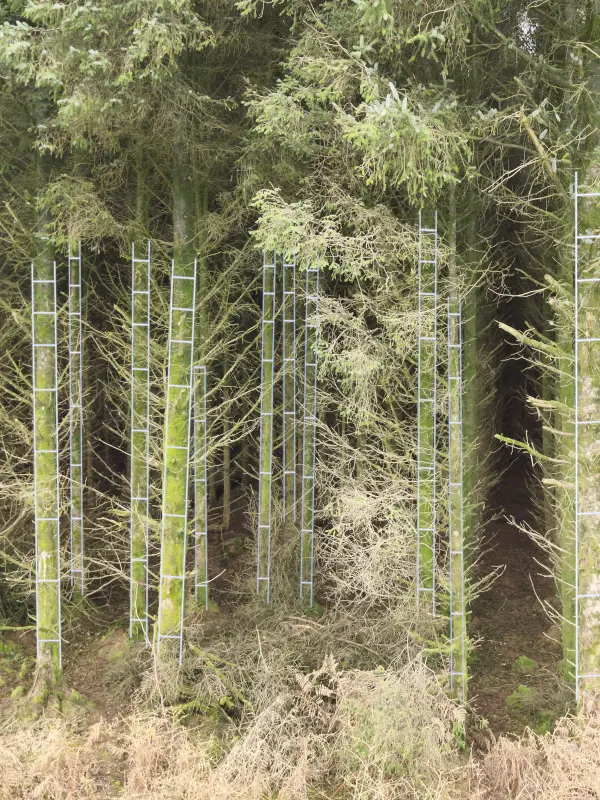
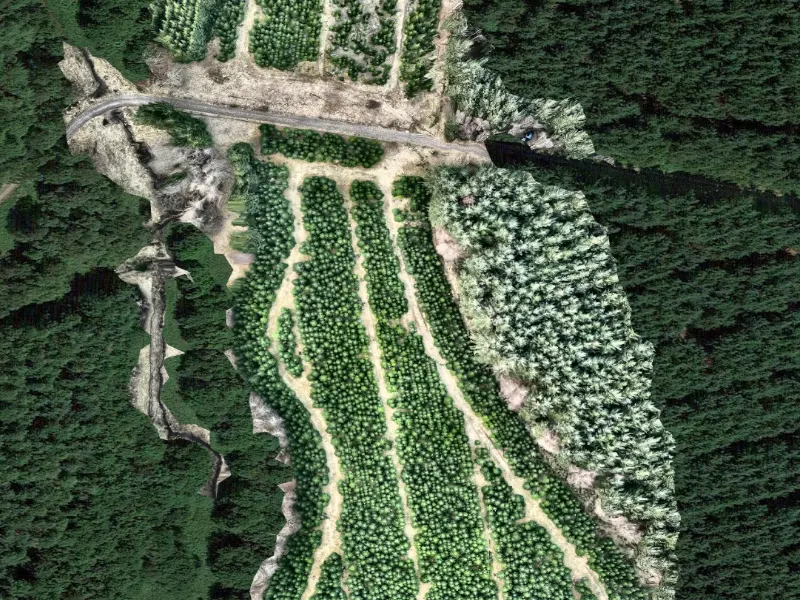
Forest Cycle Management
Forest cycle management with drones involves using unmanned aerial vehicles to monitor various stages of the forest life cycle, including planting, growth, maturity, and harvest. Drone-captured data and imagery can be used to assess the health of the forest and the trees, identify any potential issues such as disease or damage, and track changes over time. This information can then be used to make informed decisions about forest management activities such as planting, pruning, and harvest scheduling. Additionally, drones can be used to support reforestation efforts by quickly and efficiently surveying large areas for planting and monitoring progress. The use of drones in forest cycle management provides a more comprehensive and accurate view of the forest compared to traditional ground-based methods, enabling more effective and sustainable forest management practices.
Tree Girth Measurements For Harvesting And Thinning
Growth Monitoring
Disease And Pest Early Detection
Stand Density
Tree Height
Overview
Unlock the Power of Aerial Intelligence
Precision Drone Surveying and Mapping Services
Safe, Affordable Drone Data for Surveying and Mapping
Our Mission
We offer high quality professional services. using the latest technology to provide you with cost effective accurate data presented in a clear, concise manner
Our business aims to provide cost-effective and accurate data collection services using unmanned aerial vehicles (UAVs) or drones. Services such as aerial photography and videography, topographical surveys, land and property inspections, and mapping and 3D modelling. These services are use in a variety of industries such as construction, real estate, mining, and agriculture to name a few.
The main goal of the Droneza is to provide accurate data and images of a specific area, to help clients make better-informed decisions. The use of drones allows for data collection in hard-to-reach areas, with less risk to human life, and in a more efficient manner than traditional methods.
Safe, Affordable Drone Data for Surveying and Mapping
Insuarance
We are fully insured with public liability insurance with permissions for commercial operations granted by the CAA.
Pilots
Trained to the highest standard and compliant with the latest CAA regulations for commercial UAV Pilots. We are proud to be associated with Flyby Training.
Operations
Our operators are fully qualified, operating unmanned aerial vehicles adhering to strict safety and operational rules and guidelines.
Our Drones
Our drone fleet is crucial to the data you need, so we we have invested in the latest technology to ensure you get best results possible.
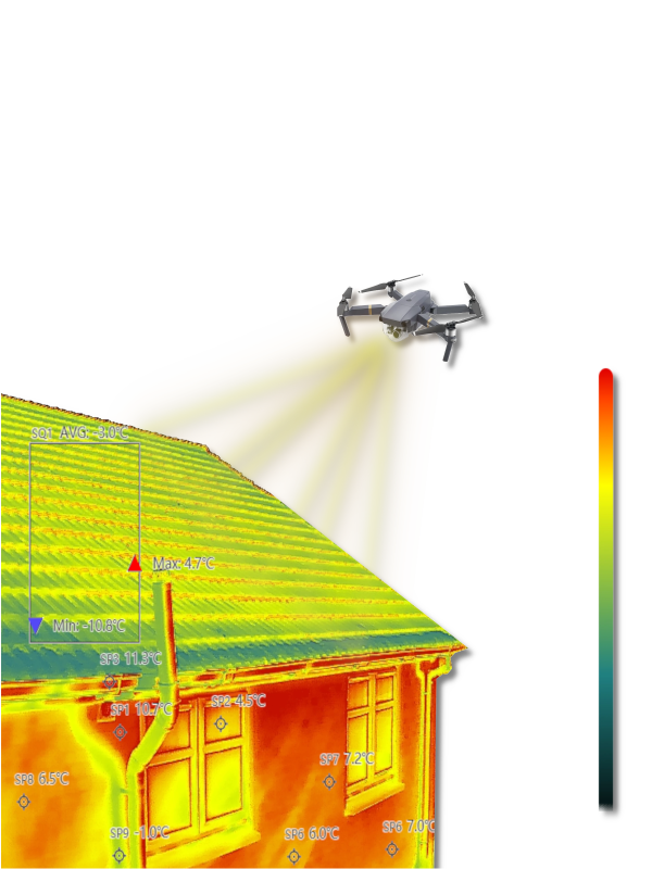
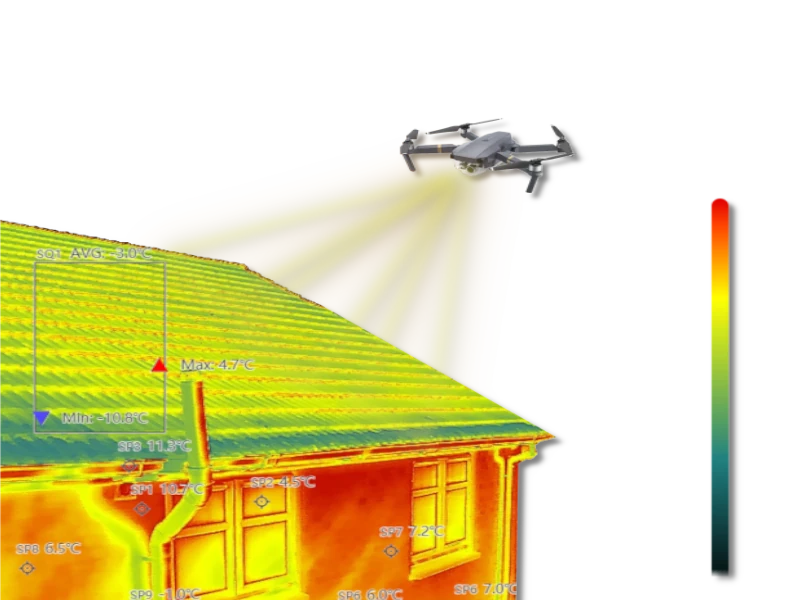
Thermal heat loss detection
Thermal heat loss detection is a process in which a thermal camera mounted on a drone is used to capture infrared images of a building's exterior. These images are then analyzed to identify areas where heat is escaping, which can indicate areas of poor insulation or other issues such as damp and leaks that may be causing energy loss. Using a drone for thermal heat loss detection allows for a safe, quick, cost-effective, and non-intrusive method of identifying heat loss issues in hard-to-reach areas, including rooftops and upper floors and windows It can also provide a comprehensive view of the building's exterior, making it easier to identify patterns or areas of concern.
Domestic Housing
Housing Associations,
Care Homes
Council Properties
Grant Applications
Aerial Photography
Elevate Your Surveying and Mapping with Drone Aerial Photography
- Aerial photography with drone technology allows for capturing high-resolution images and videos from unique perspectives and angles.
- Aerial photography with drones can be used for a wide range of applications, including real estate, construction, surveying and mapping, and events.
- The technology allows for the creation of detailed and accurate maps, 3D models and elevation data, which can be used for planning and design purposes.
Our Services
Accurate and efficient data collection for any industry
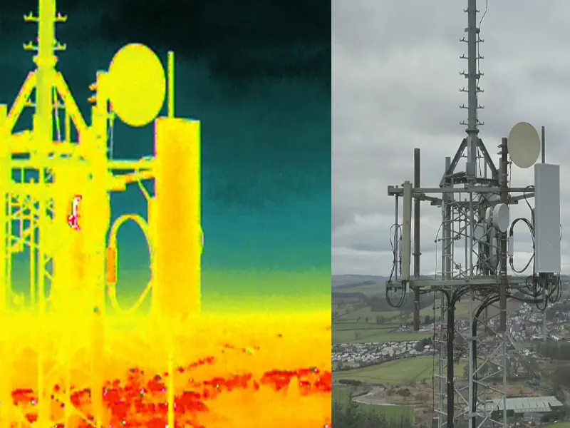
Cell Phone Towers Inspection
Drone phone mast inspection can provide a more efficient, safe, and cost-effective way to inspect and monitor cell phone towers.
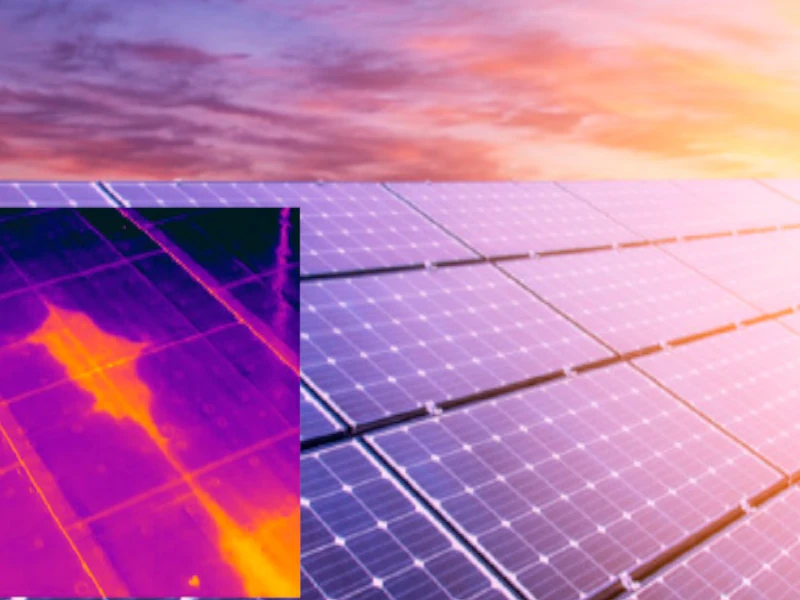
Solar Panel Inspection
Thermal imaging can detect hotspots in solar panels, which can indicate potential problems with the panel's efficiency or functionality.
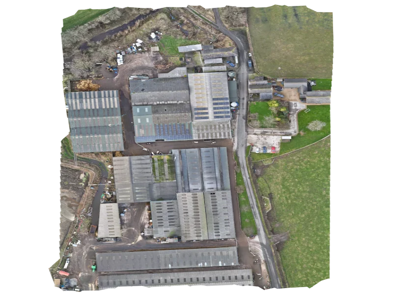
Aerial / UAV Surveys
Aerial/UAV Surveys are a cost-effective and efficient method of collecting data and creating maps using unmanned aerial vehicles (UAVs) or drones
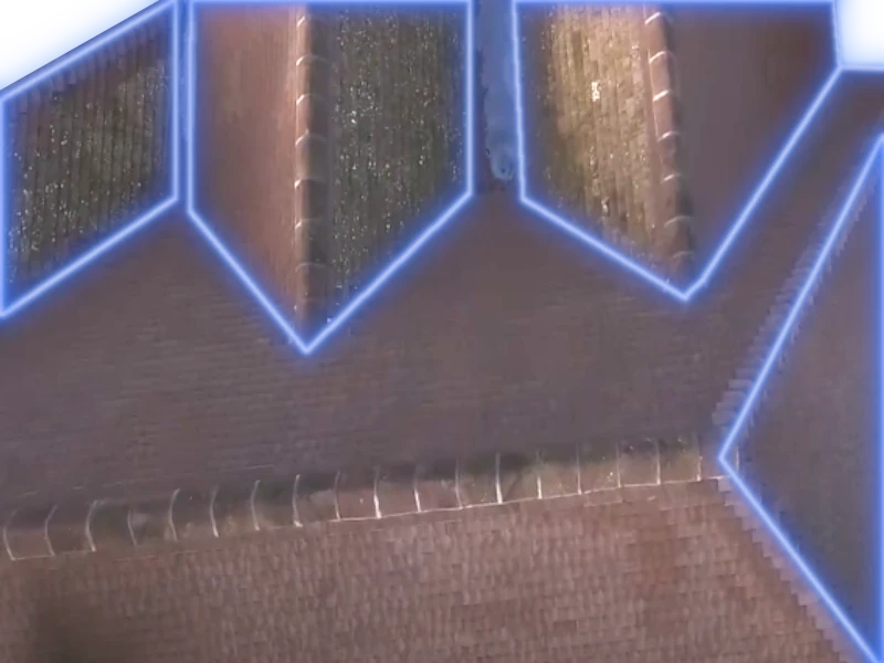
Roof Integrity
Using drones for roof integrity inspections can save time and costs compared to traditional methods and increase safety as it eliminates the need for people to access the rooftop
Deep Scan Thermography
Drones equipped with thermal cameras can capture detailed infrared images of large areas, including hard-to-reach areas such as rooftops and upper floors
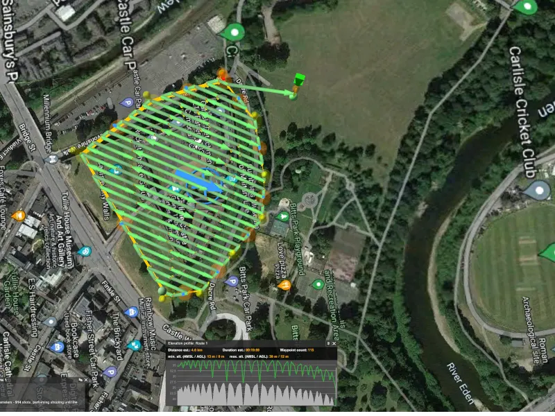
Topographical & Aerial Survey
A drone can be used to conduct both topographical and aerial surveys. A topographical survey uses drones equipped with sensors such as LiDAR to measure the
elevation and contours of the land.

Our Team
Meet Our Team

Richard Gibson
Chief Executive Officer
Sedat Pasha
Drone Pilot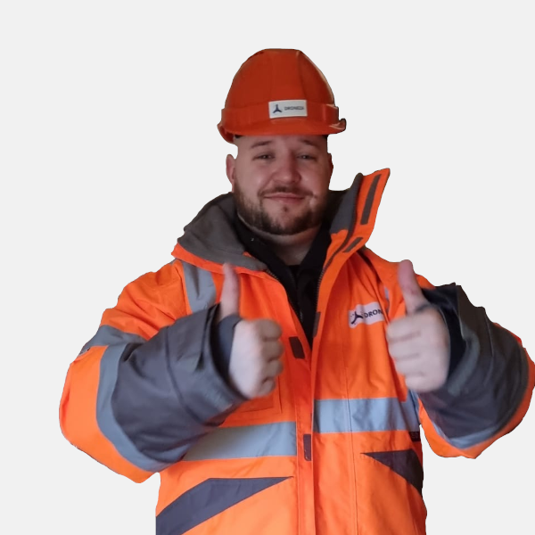
Joshua William
Drone PilotContact Us
Have any questions? We`d love to hear from you...
Get in touch
Want to get in touch? We`d love to hear from you. Here`s how you can reach us...
Email:
office@droneza.uk
Call:
0131 5263977
01228 470016